To agree with larger scale chart,latitudes taken from this chart should be increased ______ about 8 seconds.A.withB.inC.byD.to
题目
To agree with larger scale chart,latitudes taken from this chart should be increased ______ about 8 seconds.
A.with
B.in
C.by
D.to
相似考题
更多“To agree with larger scale chart,latitudes taken from this chart should be increased _____ ”相关问题
-
第1题:
No navigational aids are shown and the chart is not kept corrected for alterations in depths inside the pecked lines. For more detailed information,the larger scale charts must be ______.
A.referred to
B.appreciated
C.met with
D.concerned
正确答案:A
-
第2题:
______ is not an alarm required by IMO standards to be available on the ECDIS.
A.Deviating from a planned route
B.Approach to waypoints and other critical points
C.Light house detecting
D.Larger scale chart available
正确答案:C
-
第3题:
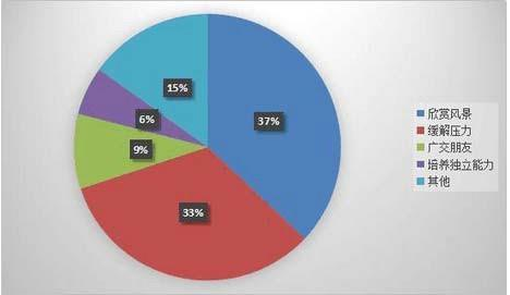
Write an essay based on the following chart.you should interpret the chart and give your comments.You should write about 150 words on the ANSWER SHEET.
 答案:解析:Portrayed in the above pie chart is a survey of college students'purposes of traveling。The number of students who take traveling as a chance to see beautiful scenes accounts for 37%,while students who would like to travell relieve pressure fr om study.
 -
第4题:
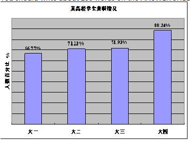
Directions:Write an essay based on the following chart.In your writing,you should interpret the chart,and You should write about 150 words on the ANSWER SHEET.
 答案:解析:The bar chart shows the general trend of university students whotake parttime jobs at different stages during their college life.Seeing from the chart,more than half of the college students,about 66.77%take a parttime job at their first year.And the proportion increases slightly year by year,til the last year,the proportion reaches the maximal number,surging to 88.24%.There are basically three reasons behind this trend.To begin with,most students are eager to take a parttime job in the purpose of earning some money,which can ease their parents'burden.Besides,they can acquire more experience before officially entering the society.And with more experience,they can easily get a job compared to those who do not have any experience.Finally,they can not only turn what they have learnt into the application,but also learn more which they cannot obtain from their books.In my view,getting a parttime job is a good practice.However,the major task of students is still the study.They should make a balance between their academic life and their working life.
 -
第5题:
单选题No navigational aids are shown and the chart is not kept corrected for alterations in depths inside the pecked lines. For more detailed information, the larger scale charts must be().Areferred to
Bappreciated
Cmet with
Dconcerned
正确答案: B解析: 暂无解析 -
第6题:
单选题A chart with a scale of 1:80,000 would fall into the category of a().Asailing chart
Bgeneral chart
Ccoastal chart
Dharbor chart
正确答案: B解析: 暂无解析 -
第7题:
单选题()chart 3994,positions read from this chart should be shifted 0.03 minutes Northward.ATo consider
BTo check
CTo examine
DTo agree with
正确答案: A解析: 暂无解析 -
第8题:
单选题That the scale of any part of a chart to be larger than the scale of the survey is().Avery rare
Bcommon
Coften
Dreasonable
正确答案: B解析: 暂无解析 -
第9题:
单选题To agree with larger scale chart,latitudes taken from this chart should be increased () about 8 seconds.Awith
Bin
Cby
Dto
正确答案: B解析: 暂无解析 -
第10题:
单选题Vessels should not anchor or trawl in the vicinity of pipelines and are()in the pipeline area shown on the chart.AProhibit to anchor
BProhibited to anchor
CProhibited from anchor
DProhibited from anchoring
正确答案: A解析: 暂无解析 -
第11题:
单选题Vessels should not anchor or trawl in the vicinity of pipelines and are().in the pipeline area shown on the chart.Aprohibit to anchor
Bprohibited to anchor
Cnot to anchor
Dprohibited from anchoring
正确答案: A解析: 暂无解析 -
第12题:
单选题No navigational aids are shown and chart is not kept corrected for alterations in depths inside the pecked lines. For more detailed information, the larger scale charts must be().Abought
Banalyzed
Cconsulted
Dpublished
正确答案: A解析: 暂无解析 -
第13题:
In very high latitudes,the most practical chart projection is the ______.
A.Mercator
B.Gnomonic
C.Azimuthal
D.Lambert conformal
正确答案:D
-
第14题:
A chart with a natural scale of 1:160,000 is classified as a______.
A.sailing chart
B.general chart
C.coast chart
D.harbor chart
正确答案:B
海图的比例尺为1:160,000是总图。 -
第15题:
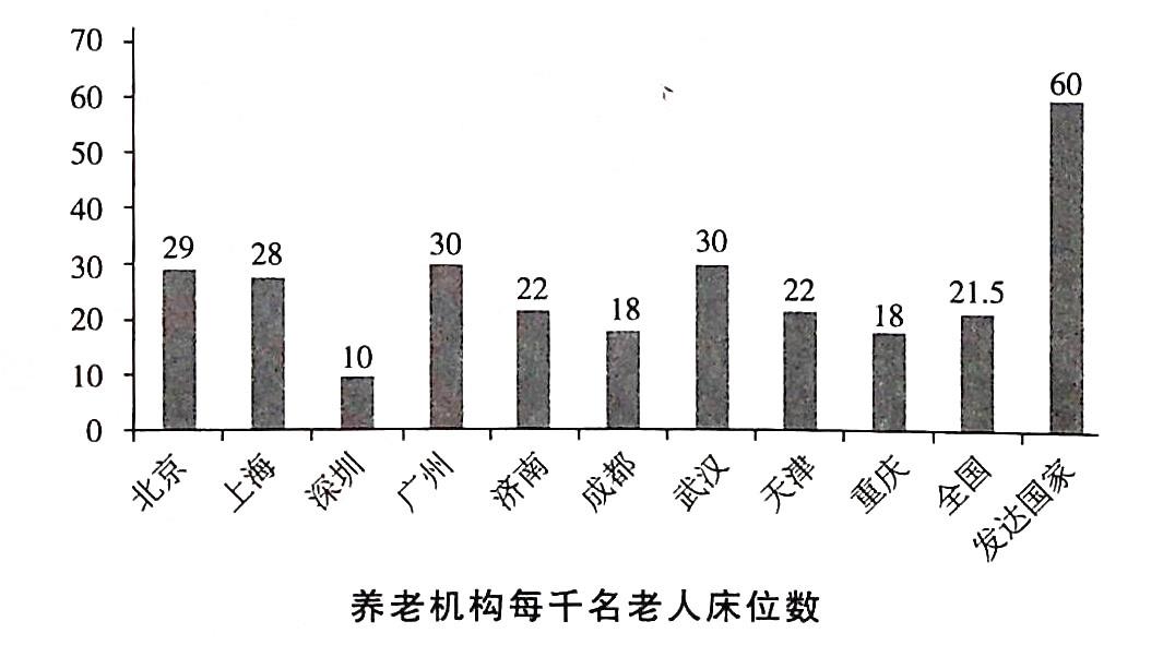
Write an essay based on the chart below,In your writing,you should interpret the chart,and give your comments.You should write about 150 words on the ANSWER SHEET.
 答案:解析:From the chart above.we can see the numbers of beds per thou.sand older people in elder-care institutions of some Chinese cities and the developed countries.Though the numbers for some cities,such as Guangzhou,Wuhan and Beijing,are higher than the average number for the whole country,which is 21.5,they are st川much lower than that of developed countries,which is 60.There are many factors contributing to the above-meniioned phenomenon,but in general,they may come down to two major ones.To begin with,the tradition of supporting the elders at home in China has hindered the development of nursing institutions.What's more,while the aging of the population is speeding up,the attention placed on the elders is insufficient.Considering the big gap between China and the developed countries,it is high time for us to take measures to close the gap.First,we.should change our idea that nursing institutions are only for those whose children don't respect them.In addition,more funds should be invested for the construction of elder-care institutions.Only in this way can we construct a society in which the elderly are looked after properly.
 -
第16题:
单选题To () Admiralty Charts 438,latitudes taken from this chart should be increased by about 5 seconds.Aconvert to
Bcome to
Clook at
Dagree with
正确答案: C解析: 暂无解析 -
第17题:
单选题Full details of all lights and fog signals are shown on().Alarge scale chart
Bsmall scale chart
Cocean chart
Drouting chart
正确答案: D解析: 暂无解析 -
第18题:
单选题Positions read from this chart should,to agree with chart 3949,be () 0.03 minutes Northwards and 0.22 minutes Westwards.Ashifted
Bremoved
Cchanged
Daltered
正确答案: A解析: 暂无解析 -
第19题:
单选题In very high latitudes,the most practical chart projection is the().AMercator
BGnomonic
CAzimuthal
DLambert conformal
正确答案: B解析: 暂无解析 -
第20题:
单选题A chart with a natural scale of 1:160,000 is classified as a().Asailing chart
Bgeneral chart
Ccoast chart
Dharbor chart
正确答案: A解析: 暂无解析 -
第21题:
单选题()is not an alarm required by IMO standards to be available on the ECDIS.ADeviating from a planned route
BApproach to waypoints and other critical points
CLight house detecting
DLarger scale chart available
正确答案: C解析: 暂无解析 -
第22题:
单选题Positions read from this chart should be moved 0.08 minutes Southward and 0.13 minutes Eastward so as () adjoining chart 344.Ato agree upon
Bin accordance with
Cto be same as
Dto agree with
正确答案: B解析: 暂无解析 -
第23题:
单选题On chart,bearings to near objects should be used in preference to objects farther off,because().Aa small error in bearing or in laying it down on the chart has a greater effect in misplacing the position the longer the line to be drawn
Ball scales are kept updated for vital information by Notices to Mariners
Cthe larger the scale of the chart,the greater the detail that can be shown on it
Dthe mariner using the medium scale charts for passage along a coast need not transfer on to a large scale for short distances
正确答案: A解析: 暂无解析
